


G-MoN

توضیحات G-MoN
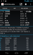
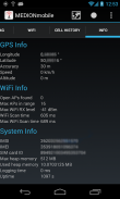
در حال حاضر آماده LTE! Fieldtest نشان می دهد LTE RSRP و RSRQ.
سطح RXL دائمی-115dBm در برخی از گوشی های سامسونگ یک اشکال سامسونگ است! فقط سامسونگ قادر به حل آن است.
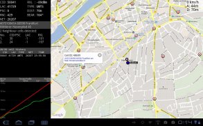
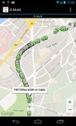
اسکنر قدرتمند WarDriving و GSM / CDMA / EVDO / UMTS و LTE Netmonitor و آزمون ابزار درایو با اطلاعیه صدا. این برای تمام شبکه های WiFi در محدوده را اسکن و ذخیره داده ها با GPS مختصات را به یک فایل بر روی کارت SD خود را. شما می توانید یک فایل KML برای کره زمین گوگل ایجاد کنید. آن را به شما نشان می دهد encrytion، کانال یک قدرت سیگنال قرار دارند. این همه اشخاص متضرر در محدوده در نقشه زنده نشان می دهد.
G-MON یک اسکنر Wardriving به جمع آوری و نقشه تمام نقاط دسترسی فای دریافت کرده است. همچنین این 2G/3G netmonitor و رشته ابزار درایو تست برای مهندسان برنامه ریزی های رادیویی. نیازهای GPS برای موقعیت صحیح در نقشه را فعال کنید!
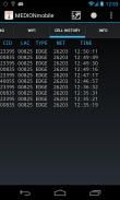
برای وارد کردن V3.0 (اطلاعات سلول اعشاری و بدون حرف مختصات) فایل CLF، تمام خطوط نظر، نام آن را import.clf را کپی کنید و آن را به / SDCARD / gmon / سپس شروع به واردات CLF از منوی.
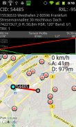
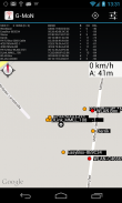
شما می توانید سطح GSM یا UMTS RX را به یک فایل KML برای Google Earth یا یک فایل CSV وارد شوید. 5 گروه رنگ برای سطوح مختلف وجود دارد. این سطح می تواند توسط کاربر در menue تنظیمات تعریف شده است. این فایل را در پوشه gmon در حافظه SDCARD یا خارجی را نجات داد. هنگامی که ورود به سیستم در حال اجرا است، G-MON نماد هشدار از طریق به قرمز تغییر رنگ. ورود به سیستم 2G/3G کار نمی کند زمانی که صفحه نمایش خاموش است!
G-MoN - نسخه 4.2.3
(13-01-2020)
G-MoN - اطلاعات APK
نسخه APK: 4.2.3حزمة: de.carknue.gmon2آخرین نسخه G-MoN
سایر نسخهها


اپلیکیشنها در دسته مشابه

شاید دوست داشته باشید...


